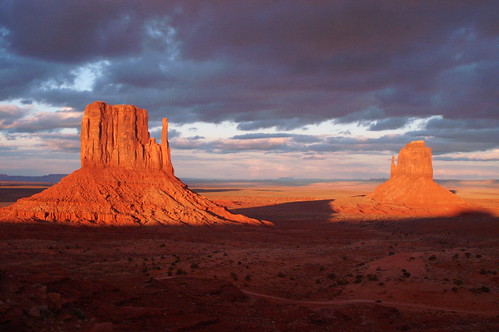
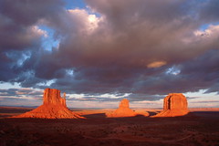
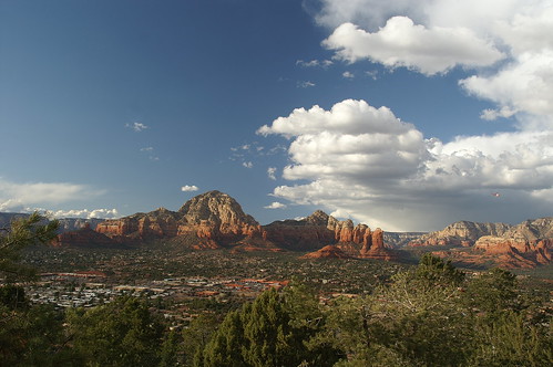
For myself I'll take Moab, Utah. I don't mean the town itself, of course, but the country which surrounds it -- the canyonlands. The slickrock desert. The red dust and the burnt cliffs and the lonely sky -- all that which lies beyond the end of the roads.-- Edward Abbey, "The First Morning,"
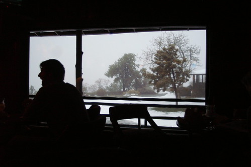
Desert SolitaireWe chased Abbey's ghost around the southwest, but of course it was in Arches where we felt his presence the most. When we first drove through town on our way to Canyonlands the day before, I looked at Main Street for some sign of familiarity from my visit back in '98, but found none, not even the Arby's where I bought lunch, until we reached the bridge over the Colorado River. I'm not sure why, but I remembered that Arby's, how I bought a chicken sandwich and curly fries (the only reason I stop at Arby's) to go and took my lunch up the road to the little park along the Colorado, just beneath that bridge. The Arby's is gone, apparently, and they're renovating the bridge, and it turns out I remember little from my previous short stay in Moab.
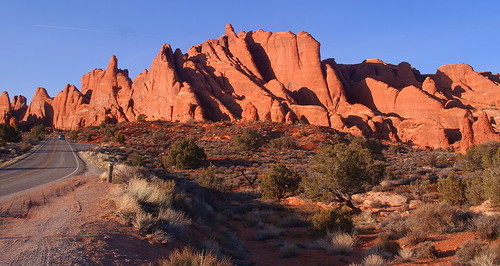
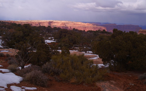
And that includes Arches. I remembered the entrance road that runs alongside U.S. 191 and I recalled the visitors center, but I had no memory of the steep climb the park road makes alongside the redrock cliffs, winding its way up into the big
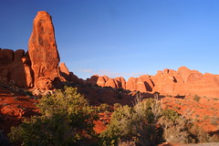
rock garden that is Arches. My memory was of the road once you finish the climb, when it opens up to a vast vista to the south, over the petrified sand dunes to the La Sal peaks on the horizon. I remembered the road curving around Park Avenue and running alongside the Great Wall, and the turnoff at Balanced Rock for Double Arch, the Windows and Turret Arch.
Desert Solitaire was the reason I first came to Arches, and after short-changing myself on that initial visit -- I believe I only was in the park from mid-morning to mid-afternoon and didn't hike the path to Delicate Arch -- I was determined to give Casey, on her first visit, and myself a full day this time. As part of my preparation, I brought both
Desert Solitaire and
The Journey Home. My reading of them -- the second time for
Solitaire, my first for
Journey -- bridged the stay in Moab, and I found that reading them after visiting the places made the images in my mind much more vivid. As a result, the time spent felt more rewarding, because I was better able to put myself in Abbey's shoes than if I'd read the books
before the trip. I found it easier to recall the park while reading the book than to recall the book while in the park.
So after re-reading Abbey's account of his
first morning in the park and
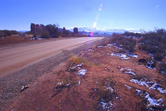
searching a bit online, I deduced the location of the house trailer where Abbey spent his summers as the steward of Arches National Monument, as it was then. I could've asked a park ranger, as that article mentions, but what's the fun of that? So before turning right after Balanced Rock to explore the Windows, we made a left on to the unpaved road that rises a hump to a picnic area and then becomes uneven and rutted as it slopes down toward Willow Flats. It then continues several miles through the backcountry and crosses Courthouse Wash before meeting Highway 191 eight miles north of the current entrance to the park. This dirt path through the desert was Abbey's way in and out of the park.
I may have been wrong, but not far from the turn off the main -- paved -- road, near the picnic area, just before the Willow Flats road deteriorated, was a clearing that currently held a few concrete barriers and other maintenance tools. It looked like the kind of clearing where a house trailer may have stood during the park's more primitive days. But the clincher, to me, was the view. This spot sat atop a bluge in the land, with Balanced Rock a few hundred yards away, the La Sal range off on the southeastern horizon and the crux of the park -- Devils Garden, the Fiery Furnace, Delicate Arch -- off to the north. Abbey
described this vantage point in his book, and with the road quickly descending past this point, I didn't see another clearing that would offer the views that Abbey had.
Abbey would probably loathe the fact that the paved park road passes so close to where his trailer sat, cutting him off from Balanced Rock and the arches past it, not to mention that the picnic area and pit toilet on the
park map (PDF) may be where Abbey built his ramada, the covered-from-the-sun, open-on-the-sides patio to escape the confined heat of the trailer when summer reached the Utah desert.
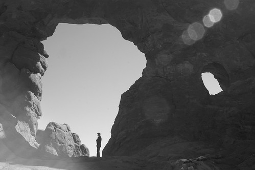
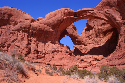
We then drove out to the Windows parking area, passing
Ham Rock on the way, and finding a relatively full lot. We walked the loop trail, stopping first to explore Turret Arch, passing through it to the other side and catching the bearded man beneath it for the photo above. I took two shots for perspective, keeping
one in color and converting that one to black and white after seeing it on the computer; it wasn't until looking at it that night in the hotel room that I saw the
resemblance to Abbey in profile and knew I'd just taken one of the iconic photos of this trip and one of my favorite shots, ever.
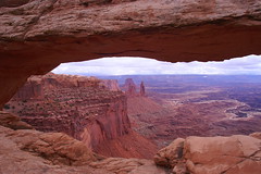
Back through Turret, we followed the path to a fork where the path on the right goes to the South Window, the left path to the North. Two women and several small children -- walking slowly -- went right; we went left. The North Window looks out on a view like that from Mesa Arch, though the drop-off through the arch isn't so sudden; you could pass through and descend to follow a path through the backcountry. Even if you don't, the vista
in front of you is a reward in itself: small canyons and rock spires scattered about the desert, leading off to Salt Wash in the distance.
Double Arch sits nearby, unchanged and sitting in the perfect morning light seen on
the WPA poster. Somehow, I missed this one back in '98, too, even though it lies a short walk from the parking area. If I did take the time to see it, I didn't take any photos, or I don't remember them. On that trip, I do remember weighing more time at some places vs. more places, but less time. I didn't have a hard end date for my trip, but I knew I wanted to try to meet my family in Maine in August. And so I told myself that it was OK if I cut a visit short -- it just meant I'd leave something to come back to see.
On the park road again, we turned to head deeper into the park, first driving past Wolfe Ranch to the Delicate Arch viewpoint, a short if at times steep trail that gives you a view of Arches' -- and one of Utah's -- most famous and iconic spots, though you're a mile away on the other side of a 500-foot abyss. It was a brief glimpse from the other side of what was to come after lunch. I basically planned the morning according to the
photography suggestions in the park newsletter. After a look at Delicate Arch and a quick stop at
Wolfe Ranch for some photos with the right light, we drove back into Moab to refuel with burgers at
Milt's Stop and Eat.
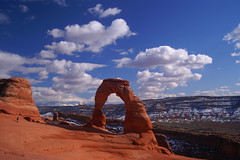
Fortified with beef and cheese and tots, we returned to the park and began the mile-and-a-half trek to Delicate Arch. It's an arduous and varied hike, first through the brush around Salt Creek, then up a small switch-backed rise and down and up again as you approach the long climb
up the sandstone, where Abbey noted that the legions of tourists have left a noticable path from cairn to cairn on the rock. At the top of this stretch, the walk becomes more pleasant, winding and dipping and rising slightly again through a pleasant collection of rock formations, juniper, sagebrush and damp, muddy pockets. The final push covers a ledge cut
out of a cliff -- on the shadowy side, so that much of where we trod remained covered in snow and ice, but thankfully it angled in toward the cliff wall rather than out toward the slope.
And then, you're there. I shouldn't have even tried to describe it myself;
Abbey does a fine job of it:
Many have made the climb to Delicate Arch, so many that the erosion of human feet is visible on the soft sandstone, a dim meandering path leading upward for a mile and a half into a queer region of knobs, domes, turrets and coves, all sculptured from a single solid mass of rock. What do the pilgrims see? The trail climbs and winds past isolate pinyons and solitary junipers to a vale of stone where nothing has happened for a thousand years, to judge from the quietude of the place, the sense of waiting that seems to hover in the air. From this vale you climb a second ledge blasted across the face of a cliff, round a corner at the end of the trail and Delicate Arch stands before you, a fragile ring of stone on the far side of a natural amphitheatre, set on its edge at the brink of a five hundred foot drop-off. Looking through the ring you see the rim of Dry Mesa and far beyond that the peaks of the La Sal Mountains.
There are several ways of looking at Delicate Arch. Depending on your preconceptions you may see the eroded remnant of a sandstone fin, a giant engagement ring cemented in rock, a bow-legged pair of petrified cowboy chaps, a triumphal arch for a procession of angels, an illogical geologic freak, a happening -- a something that happened and will never happen quite that way again, a frame more significant than its picture, a simple monolith eaten away by weather and time and soon to disintegrate into a chaos of falling rock. ...
If Delicate Arch has any significance it lies, I will venture, in the power of the odd and unexpected to startle the senses and surprise the mind out of their ruts of habit, to compel us into a reawakened awareness of the wonderful -- that which is full of wonder.

We sat up there for a good half-hour, at least, and could've stayed longer, but there was more we wanted to see. Our stay happened to fall within the departure of some of the more voiciferous people who had been there before us and we left just as a new collection of hikers arrived; for the most part, we had a quiet and serene stay for ourselves.
Though there were the two items that slipped from their owners' grasps and rattled down the rock into the amphitheater: a plastic water bottle one couple accidentally kicked down the slope as they stood up to leave, and the camera lens of a photographer who had been
crouching in a small level ledge a few feet below where we sat. I nervously watched him taking his shots, his boots holding him onto the sandstone slope. When he shimmied back up to his jacket and started changing lenses, I further questioned his judgement. And then, as I was drawing Delicate Arch in my notebook, I heard the sound of metal and plastic bouncing off the red rock. I looked down, he looked up, and I said, "That didn't sound good. Was it a lens?" He nodded: "Guess I'm going for a hike."
He walked around to the base of Delicate Arch, then sat on the slope and considered whether he could get down into -- and back up from -- the bottom of the amphitheater. It forms a basin, with a patch of soggy sand -- including rather recent footsteps -- a juniper and some sagebrush. At the opposite end, it appears to connect to more stable ground, perhaps accessible to the trail, with only a small wall blocking it from view.
After some thought, he abandoned the plan and started the walk back along the trail. As Casey and I began our walk down, I could see him ahead. Before long, he wasn't there anymore, so I suspect he went off-trail to find another access point to the amphitheater to retrieve his lens.
I took note of the time -- our walk down took maybe half an hour, after a 45-minute trek up -- and noted the groups we passed that were heading up to the Arch. Nearly down, we came across a couple, their two children -- one a toddler strapped to Mom's back, the other a daughter walking up with grandma -- and wondered how they'd get to the top in time, let alone down before the shadows started settling into the nooks of the canyon. But that wasn't our concern -- we headed deeper into the park along the road, passing the Fiery Furnace as it lived up to its name in the late-afternoon light. The road, which had descended from Panorama Point into Salt Valley, began rising again as we approached Sand Dune Arch, Broken Arch and Skyline Arch on our way to the park campground.

We got out for one more hike that we hoped would take us in a loop from the end of the campground road to Broken Arch and back, but after a brief detour that took us to a quiet view of an arch whose name escapes me at the moment, we were beat. The sun had ducked behind the rock wall behind us and the shadows stretched across the terrain in front of us. Weary and tired of tromping over the snow, still ankle- and knee-high in places, we decided to call it a day and, essentially, a vacation.
Driving out of the campground, we noted the campers as they stoked their fires and began to settle in for the night. We turned onto the road again, driving past Devil's Garden, the 7.2-mile trail and collection of arches at the very end of the park road, and began to make our way out of the park. So deep into Arches were we that it took about 45 minutes to drive the 20-something miles from Devil's Garden back into Moab to our hotel. After showering, we walked across the street back to Moab Brewery, settling in at the bar for more hard-earned food and a couple of pints.